Submerged aquatic vegetation (SAV) in Currituck Sound provides essential ecosystem services, including habitat for fish and birds, shoreline stabilization, and water quality improvements. SAV growth is constrained by light availability, making it highly sensitive to water clarity. The planned Mid-Currituck Bridge raises concerns about potential impacts to water quality, SAV, and shoreline stability in this shallow estuarine system.
This two-year study evaluated spatial and temporal patterns in water quality, SAV distribution, and shoreline change to guide impact reduction and mitigation strategies. In year one, we conducted monthly sampling at 13 sites, continuous sonde monitoring at 1.9 m depth, Sentinel-2 remote sensing of turbidity, hydroacoustic and drop-camera SAV surveys, and shoreline monitoring with drones and wave gauges.
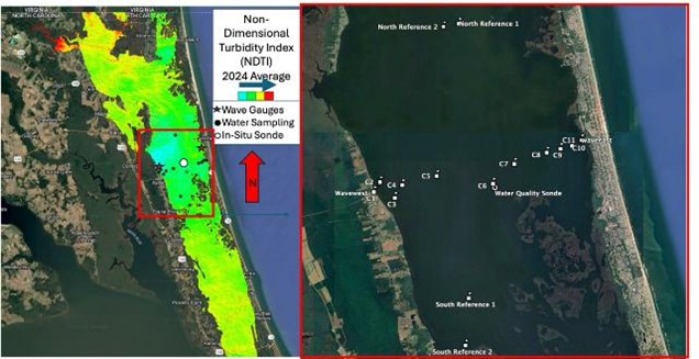
Image of Non-Dimensional Turbidity Index (NDTI) average
for 2024, an overview of research area and an inlay map of field sites.
Results show SAV within the bridge footprint increased by ~400% since 2021, now covering nearly 58 acres. SAV depth limits have expanded from 1.8 m (2017–2018) to at least 2.4 m, suggesting improved water clarity. Water is more turbid north of the bridge, but SAV-dominated zones exhibit lower turbidity, indicating positive feedback between SAV and water quality. Long-term comparisons reveal declining turbidity and increasing salinity since 2018, though episodic spikes during storms highlight system vulnerability. Shoreline erosion is ongoing, with greater loss on the western shore.
Overall, results suggest that while construction poses risks, mitigation of SAV impacts is achievable if water quality is maintained. Protecting existing SAV beds and targeting mitigation in areas of sufficient light availability will be critical. Continued monitoring will refine thresholds for effective mitigation during year two.
