This research project aims at providing the North Carolina Department of Transportation with a computational tool for predicting freeway lane change intensity near interchange influence areas (IIAs). The intent was to use data that are readily available to traffic engineers and analysts in the state to generate those predictions. The proposed model estimates the total number of lane changes on a freeway segment using two different sub-models, one that assumes knowledge of the number of the mandatory or minimum number of lane changes (MinLaneChanges), and a second model that does not. The first model is applicable to existing interchange areas where ramp volumes are known, while the second can be used for new interchange analyses at the planning stage. Data needed to develop the prediction tool included both geometric and traffic stream variables. A total of fifteen sites in North Carolina were videotaped using a combination of ground based and drone fitted cameras. Lane changes were tracked using video tracking software in 5 minute time intervals, subsequently expanded to hourly rates.
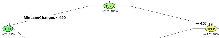
Overall, the average observed number of lane changes across all sites and time intervals was 1,373 lane changes/hour (lc/h). The range of the response variable for the first model with known MinLaneChanges varied from a low of 251 to a high of 3,798 lc/h, and for the second model absent MinLaneChanges from 343 to 3,816 lc/h. Generally speaking, low rates of lane changes were associated with low values of MinLaneChanges, short segment lengths, low vehicle miles of travel (VMT) and low average speed. The first explanatory variable in the tree absent MinLaneChanges was the actual segment length, with longer segments generating higher lane change rates. Interestingly, we found from the first model, that when MinLaneChanges fell below 450 lc/h, the total lane changes per hour were only about 22% of those occurring when MinLaneChanges exceeded 450 lc/h. Furthermore our observations of the data indicated that lane change frequency decreased as the level of congestion increased. The two models have been implemented in a prototype web-based tool, which includes a computational engine, along with a user guide and an input variables calculator. Further work on testing and validating the web tool will resume when physical access to the NC State University campus facilities is permitted.
In addition, the research team tested a proposed geometric treatment that was intended to reduce lane change frequency at the I-40EB weaving segment between Harrison Blvd. and Wade Avenue. The testing methodology was microsimulation using the VISSIM microsimulation model. The model was calibrated based on observed Origin Destination (OD) flow distributions and OD travel times measured from field Bluetooth units at the site. Key findings from this analysis revealed that the treatment generated total travel time saving of 16.2 veh-hours per clock hour, which is applicable to two hours in the PM peak on a typical weekday. The treatment did reduce the simulated overall lane change frequency by a significant 22%.