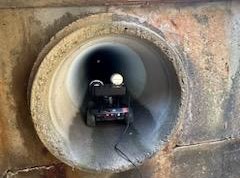
This project aimed to implement the advances in new technologies to develop a robotic-based autonomous inspection system for underground pipelines. The new technology is based on the combination of intelligent powerful portable software and the newly advancement in mapping techniques. The system can scan and reconstruct the 3D profile of a pipeline in real-time using a networked system of ground robots. LiDAR (Light Detection And Ranging), Infrared (IR) cameras and 3D cameras with other NDT (Non-Destructive Testing) sensors used to generate the 3D profiles of the pipes as the robots with the advanced sensors autonomously move inside the pipes. During the pipe condition assessment, video files, pictures, and other scans like LiDAR and 3D are used to acquire a lot of data. This becomes cumbersome to interpret and make meaning out of. In the context of human decision-making, we aim at reducing and reordering the data to show to the human inspectors to enhance their decision performance. The proposed method is based on computer vision and pattern recognition algorithms that have proven to improve the proficiency of the inspection process in identifying and locating important features and defects. A complete technology transfer system is developed and proposed to NCDOT for implementation.