Howard Gap debris slide and other mapped slope failures in this area have adversely impacted public transportation and utility infrastructure, private property, and threatens public safety. In order to assist NCDOT with landslide monitoring, the proposed research aims to create an effective 3D-geospatial framework by integrating field monitoring data with high-resolution remote sensing data (from UAV optical, LiDAR and SAR) using machine learning methods to assist in further understanding the mechanics of this large debris slide, and to remotely monitor other landslides that impact North Carolina transportation corridors and the citizens of NC.
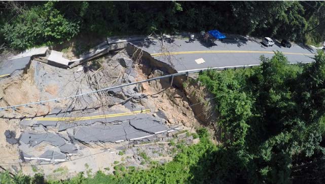
Displacement along the main scarp of the Howard Gap slide
The study will leverage freely available satellite imagery to improve the Howard Landslide monitoring by expanding the spatial extent from point sampling to whole area characterizations while reducing associated time and cost compared to the current techniques. In addition, a predictive model using machine learning methods will be developed to hindcast over the last few years and forecast the occurrence and extent of future debris –flow and slope failure.
The research methods and outcome (codes and spatio-temporal tools) can be used by NCDOT to monitor landslides at other locations in North Carolina establish an early warning system for the area to predict the landslide displacement and quantify the uncertainties.
