Landslides are one of the most significant geohazards impacting North Carolina's transportation network, causing fatalities, property loss, and long-term economic disruption. These events are frequently triggered by extreme precipitation from hurricanes and tropical storms, which have historically produced hundreds to thousands of debris during a single event. For example, Hurricane Helene (2024) triggered more than 2,000 reported landslides across the Southern Appalachians, resulting in widespread road closures, bridge damage, and tens of billions of dollars in direct and indirect losses. As the frequency and intensity of extreme precipitation events increase, the risk of cascading infrastructure failures is expected to grow. Current NCDOT Geotechnical Asset Management (GAM) tools primarily operate reactively— tracking known unstable sites and coordinating post-disaster repairs. Therefore, there is a critical need for proactive capabilities to anticipate landslide hazards before they disrupt the network.
The objective of this project is to create a robust, scalable, and computationally efficient framework to predict landslide triggering and runout at a regional scale, supporting optimized maintenance, emergency response, and risk-informed investment decisions. This work will integrate the North Carolina Geological Survey (NCGS) Post-Helene Landslide Inventory, surface deformation mapping, and AI enhanced triggering predictions. The research will pursue four main objectives: (1) consolidate and curate a high-quality georeferenced dataset of landslide and debris flow events in North Carolina; (2) develop machine-learning models informed by physics to predict triggering susceptibility based on rainfall thresholds, slope geometry, and hydrologic conditions; (3) link surface deformation signals to slope stability through finite-element-based surrogate models; and (4) compute landslide runout using depth-averaged Material Point Method (DA-MPM) simulations that account for three-dimensional topographic effects and infrastructure exposure.
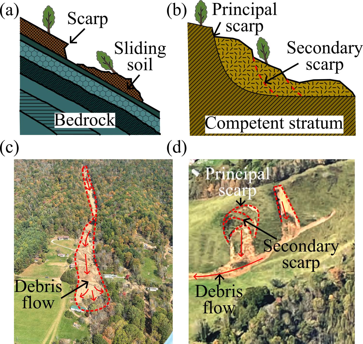
Schematic of two basal configurations leading to distinct sliding mechanisms: (a) translational sliding over bedrock and (b) rotational sliding over thick soil strata. Examples (c and d) illustrate landslides from Hurricane Helene consistent with these mechanisms. Figures modified from Allstadt et al. (2025)
Our approach follows a hierarchical and computationally efficient workflow. Regional-scale data-driven models will rapidly screen the entire state for slopes with high triggering potential. For these critical sites, limit equilibrium analysis (LEA) using existing NCGS models will identify likely failure surfaces and factors of safety. The outputs will serve as inputs to physics-based DA-MPM simulations that predict debris flow runout, impact zones, and potential consequences for NCDOT-managed assets. This strategy maximizes coverage while focusing on high-fidelity simulations where they are most needed, thereby balancing predictive power with computational cost.
The anticipated products include trained machine-learning models, enhanced infinite-slope analysis incorporating AI training, a verified and validated DA-MPM module, and GIS-integrated hazard/risk maps. Integration into NCDOT's existing GAM system will enable decision-makers to: (i) develop watchlists of critical slopes, (ii) anticipate maintenance and debris removal needs, (iii) coordinate detour planning and emergency response, and (iv) communicate risk more transparently to stakeholders. Training workshops will be held with NCDOT and NCGS engineers and geologists to ensure usability and gather feedback for future system enhancements.
This project represents the first step toward a real-time, data- and physics-informed landslide early warning and infrastructure risk management system. By combining machine learning, geotechnical modeling, and large-deformation simulation, this work will strengthen North Carolina's landslide risk assessment and improve transportation resiliency, reduce lifecycle maintenance costs, and protect the safety and mobility of the traveling public.